I have always been told to go to Huaraz and witness the Cordillera Blanca. I have never had the opportunity to do it and I thought I was gonna miss it this year because I didn't have any trekking partners. In step Nikki and Chris, BAM, trekking partners and great ones at that! The only problem is that we are in Arequipa, southern Peru, and Huaraz is in northern Peru. I've already been to northern Peru on this trip, but what the hell! So we got on the 18 hour bus, connect in Lima with the 10 hour bus and arrive in Huaraz 30 hours later. We spend the next day figuring out a game plan for our trek. We find out that the best trek for this time of year is the Santa Cruz trek because it is the middle of the rainy season, hmm rain, sounds like fun!
There are two ways of attacking the beast, the most common way and the way the tour groups go is to start in Vacaria and go towards Cashabamba. This brings you to the pass the second day. If you go the opposite way you hit the pass on the third day. We mulled it over and decided to take the road less traveled, best decision we ever made!
 |
| Day 1 trekking, Nikki on her way up |
Day one begins at the mouth of the valley, we are facing a steady climb of 800 m (2,625 ft.) to the first campsite. It takes us 5 hours, 5 exhausting hours, let's say that the trekking legs are not 100% yet. Carrying a 30 pound pack and a non stop climb took it's toll on this old man. But it was worth it because we had perfect sunny weather in the 50's and the natural beauty of the valley was incredible. We got to camp and we were the only ones there, perfect. There was just enough time to cook up some tacos and eat before the sun went down and the chill set in. The tempuratures at night hovered around freezing, so the sleeping bags were essential!
 |
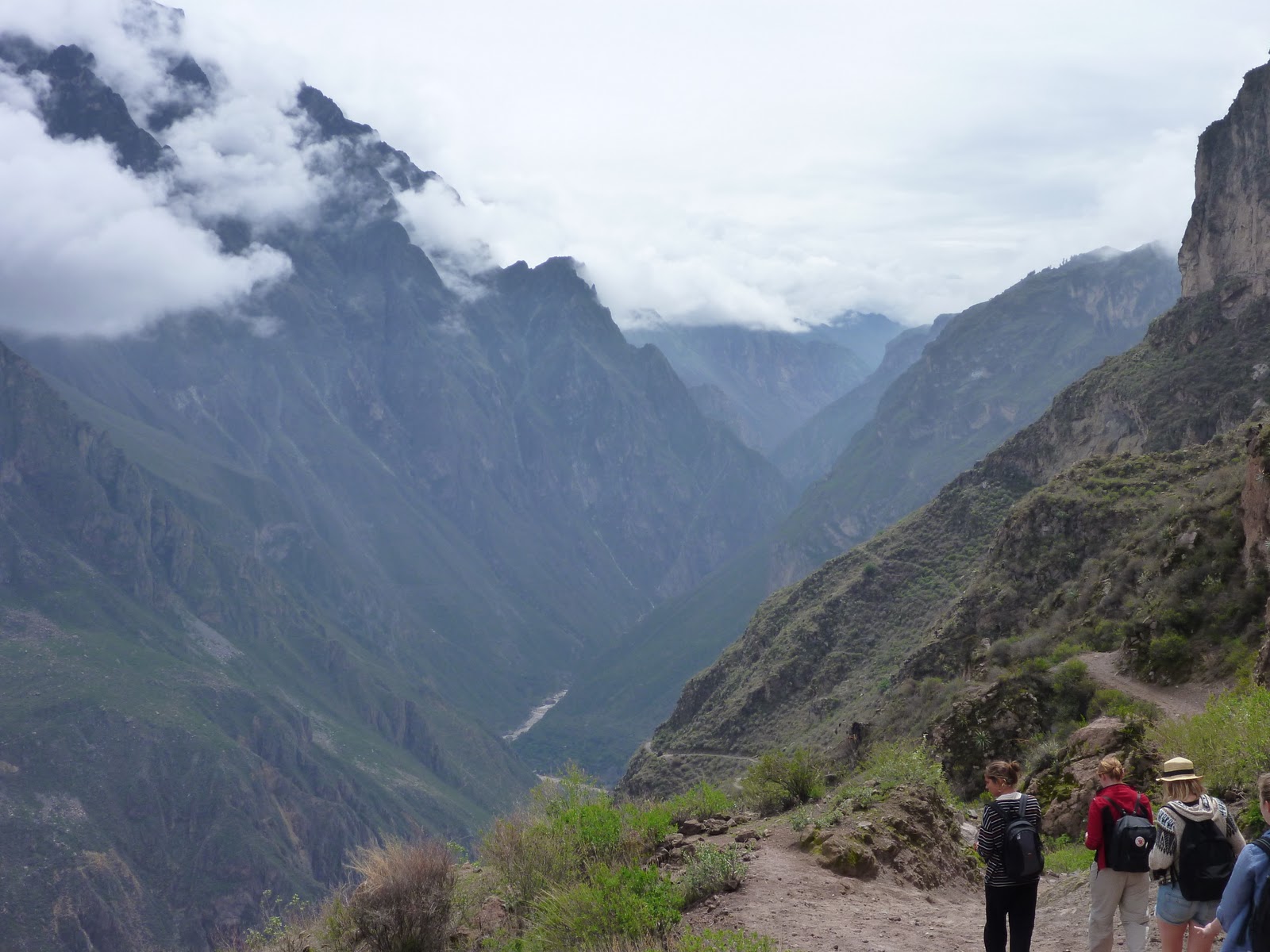
| Second day - along glacial lagoons |
 |
| Surrounded by glacier covered mountains |
The next day we rose a bit late, but once again the sun was shining, the trekking gods were smiling down upon us! We packed up and began another 800 m steady climb, or so we thought. The valley ahead of us was overcast and looked cold. But as we advanced, the clouds broke and the sun shined on us all day! It took us 3 hours to get to the campsite prior to the one we planned on staying at. The trail was suprising level along glacial lagoons and we were plugging along at a good rate. We should have made camp within two hours, the only problem was that we were on the wrong side of the river! Yes, we lost the trail! We began to make the difficult hike back along the river looking for a safe crossing, none. Stop, eat, think this over. The only answer was to back track to the wetland and try to cross the river there where it is forked. After two hours of back tracking and crossing narrow but deep channels we finally got to the right side of the river. There we found three folks sitting around enjoying the sun. They told us that they came across the pass yesterday and this is the first time they had seen the sun. It seems the path we took was the correct on, at least so far! At this point we've been carrying our packs for five hours and had about 2 hours to go. Easy, right? No, the trail turned up, and up some more. The last two hours were hell, but the reward at the end was worth it! Our campsite might have been one of the most incredible campsites in the world, see new picture at top of blog. Nestled at the end of the valley at the foot of the Nevado Taulliraju.
 |
| Nikki making the final ascent to the pass |
The third day it was up early to begin our 300 m (984 ft) climb to the pass. A quick breakfast and we were off. It took about two hours. The climb to the pass was basically walking up a stream with a loose stone substrate. It seems that all the melt and rain from the mountain was everywhere, in particular along the ascent. There were areas where the trail became solid rock, slippery solid rock. There were sections where bouldering techniques were necessary. This was not an easy ascent, but really, when is it ever! We finally made it to the top, and the feeling of completeing a phsyically challenging feat is beyond words. I was out of breathe, sore, tired and hungry, but I felt like I was on top of the world. I sort of was, the pass is at 4,750 m (15,584 ft). We spent some time taking it all in, sun on the side that we came from and overcast and rain in the direction we were headed.
 |
| The view decending the mountain |
After a nice rest, it was time for the decent. The beginning was steep and included switchbacks, slippery and loose rocks and generally steep grade down. We arrived after 7 hours of hiking at the campsite at 2 in the afternoon. An early arrival, we had decended 880 m (2,887 ft) and were ready for a nice relaxing afternoon. The reason, we realized, that our reverse route was 100% better than the normal route is because the descent. If we had done the opposite, we would have had a 8 hour hike on day two of all switchbacks and hell trail to reach the pass, we are wise folks people, wise!! We settled in and finally it was payback for the sunny weather we had to endure, about 5 PM the rain came with some nice hail. Time to hunker down in the tent and warm up some food. It was actually nice to spend the evening in the tent, reading and enjoying the sound of raindrops hitting the tent.
 |
| Civilization!! |
A lazy start on the final day brought a pituresque 3 hour hike to the town of Cajatambo. It was a great way to end four days of trekking. The first signs of civilization in four days brought friendly smiles from locals. They all waved at us, gave us helpful hints and were happy to see the three gringos and their packs. I often think about what the locals must think about the way we get all geared up for these things, when they climb these passes many times in their lives with no advanced gear, much less footwear. It must be a bit comical to them!
Everything was going smooth and fine, until I slipped on a rock, go figure, that never happens. Either does the outcome, more bruised ribs, my favorite. But, we trekked on, got to Cajatambo expecting to find the collectivo waiting for us. Exhusated and happy to be at the exit point, I asked a really nice old lady sitting in front of her Bodega at what time the collectivo arrived. She looked at me and said the collectivo hasn't come here since the 80's when they built the new road to Vacaria. Huh, news to us. I asked her where Vacaria was, she pointed up and said at the top of that mountain. Huh, that sucks. How long will it take to get there? A little over an hour. And it's up there, on top of that mountain? Yes, that one. There are no cars that go up there? No, no cars ever come here. And it's up, right? Yeah, straight up that mountain. Hum, great news, thanks. Well the journey never ends and we got our packs on for one last acsent. An hour later we arrived at Vacaria dropped our packs and cursed high altitude hiking!
There we were, just in time for the collectivo. Game over, right? Never! For those of you who do not know what a collectivio is, let me express what we were getting into. This particular collectivo was a blue 17 passenger van with 20 people in it. Which isn't bad because these things ussually have 30 people in them. Nikki and I sat in the back, wedged in like sardines, while Chris was in the front with all kinds of leg room. It was to be a two hour ride to Junga. First we had to drive switchbacks up the mountain to a pass. Incredible sights, it never gets old! We made it to the top with no problem and began the descent. Again a series of switchbacks that never ended. At one point the driver, Don Pepe, pulled over. Huh, what's this, bathroom break, how thoughtful! No, flat tire. No biggie, that has to be normal on the incredibly bumpy road made of gravel and boulders. In ten minutes Don Pepe had us on the road again. A few more switchbacks later and we pull over again. What now? Broken steering fluid line, this might take a little longer. Nope, Don Pepe got under the van, hammered on something, busted out the duct tape and we were on our way!
We made it to the bottom of the mountain and things were going great, when tradgedy struck. I didn't see exactlly what happened, but apparently the right rear tire flew past the front of the van, while the rest of us felt the huge clunck and heard the digging of the rear right axle into the gravel road! We get out and the tire was about 100 m ahead of the van, the rear break drum was about 100 m behind the van and lug nuts scattered everywhere.
This is where I got worried, atleast 20 km from Yunga, brokedown along the side of a gravel road, literally in the middle of nowhere. But, than a strange thing began to happen, as the locals got off the bus they all began looking for parts that may have fallen off the van, this is obviously not the first time something like this has happened. As they were collecting parts, Don Pepe was accesing the situation. Once all the parts were recovered, he attempted to get the jack under the axle. No go, it was buried in the gravel. He grabs a rock and instructs all the male passegers to lift the vechicle. Alright, we all lift and push, he gets the rock under the axle. Not enough room for the jack, bigger rock and 1-2-3 lift! Nope, bigger rock, repeat, and repeat again! After the fourth rock, the jack is in place. Piece by piece the brake is reassembled, and tire place on, 45 minutes later we are on the road and finally arrive safetly in Junga.
An amazing four day trek, with the wonder of nature surronding us. And we got the bonus collectivo ride from hell!! Loved every second of those four days. In fact I have loved every minute of being in Peru for a month. It is time to move on, Bolivia here I come!! I leave you with some pictures of my home land, I love her and she will be missed!!
 |
| Peruvian sunset at Mancora |
 |
| Santa Cruz River alongside the trail |
 |
| Trekking the Santa Cruz valley |
 |
| Punta Union Pass - 15,584 feet |
 |
| Mi Familia en Lima |


No comments:
Post a Comment